Key points
- In a straight line, about 98% of India's people live within 5 km of some listed public health facility, mostly a sub-centre.
- Counting district, sub-district and medical college hospitals, about 477 million people live more than 20 km in a straight line from one. Counting community health centres too, many of which act as first referral units, that falls to about 73 million.
- These are measures of distance, not travel time or access to care, and they depend on the completeness and labelling of the facility list.
How far people live from health care depends on which part of the health system they need. A primary facility may be close by, while a hospital that can perform a caesarean section or give a blood transfusion may be much farther away. I wanted to see what that difference looks like across India, using public data.
This is an independent mapping exercise. It measures straight-line distance from where people live to listed public facilities. It does not measure travel time, the services a facility actually offers or whether people can use it, and it is not an official assessment of India’s health system. It is built from data available publicly online, which may be dated in places and may not be an exact representation of facilities and boundaries on the ground.
How I measured it
I took a public list of 227,091 government health facilities with coordinates, from the National Identification Number (NIN) facility directory (April 2026), and the Survey of India’s state boundaries. I divided India into about 4.1 million grid squares of about 1 km each (30 arc-seconds), and for every square calculated the great-circle distance to the nearest facility in the list. Only facilities in India’s list were used, so a facility just across an international border is not counted.
I did this for any facility, for primary facilities (sub-centres, primary and urban health centres, dispensaries) and for public hospitals, under two definitions.
- District, sub-district and medical college hospitals, which gives 2,216 facilities. I grouped these together because states label their hospitals differently in the list. Haryana’s civil hospitals, for example, appear as sub-district hospitals.
- The same, plus community health centres, which gives 8,215 facilities. Many community health centres act as first referral units and provide services such as caesarean sections, although not all do.
Then I weighted each square by the number of people living in it, using WorldPop’s 2020 population estimates for India, which are modelled at about 1 km and adjusted to UN national totals. The facility list is from 2026 and the population estimates are from 2020, so the results describe distance under these two datasets, not an exact count of people today.
First contact is close, the hospital less so
| Straight-line distance | Any public facility | District, sub-district or medical college hospital | Adding community health centres |
|---|---|---|---|
| Within 5 km | 98% of people | 19% | 36% |
| Within 10 km | 99.8% | 36% | 68% |
| Within 20 km | 99.96% | 65% | 95% |
| More than 20 km | about 0.5 million people | about 477 million people | about 73 million people |
| More than 50 km | about 40,000 people | about 28 million people | about 0.7 million people |
The first column reflects the large network of sub-centres and primary health centres built over decades. Outside a few deserts, mountains and islands, a listed public facility is within 5 km in a straight line for nearly everyone. Primary facilities alone give almost the same result, because sub-centres make up most of the list. Being close in a straight line does not by itself show how easy a facility is to reach, or which services it provides.
The other two columns show how much the answer for hospitals depends on what is counted. With district, sub-district and medical college hospitals only, about half of India’s people live more than 15 km in a straight line from one, and the population-weighted average is about 17 km. When community health centres are added, the average falls to about 8 km and the number more than 20 km away falls from about 477 million to about 73 million. Which definition is closer to the truth for a given need, such as emergency obstetric care, depends on what each facility can actually do.
Land and people tell different stories
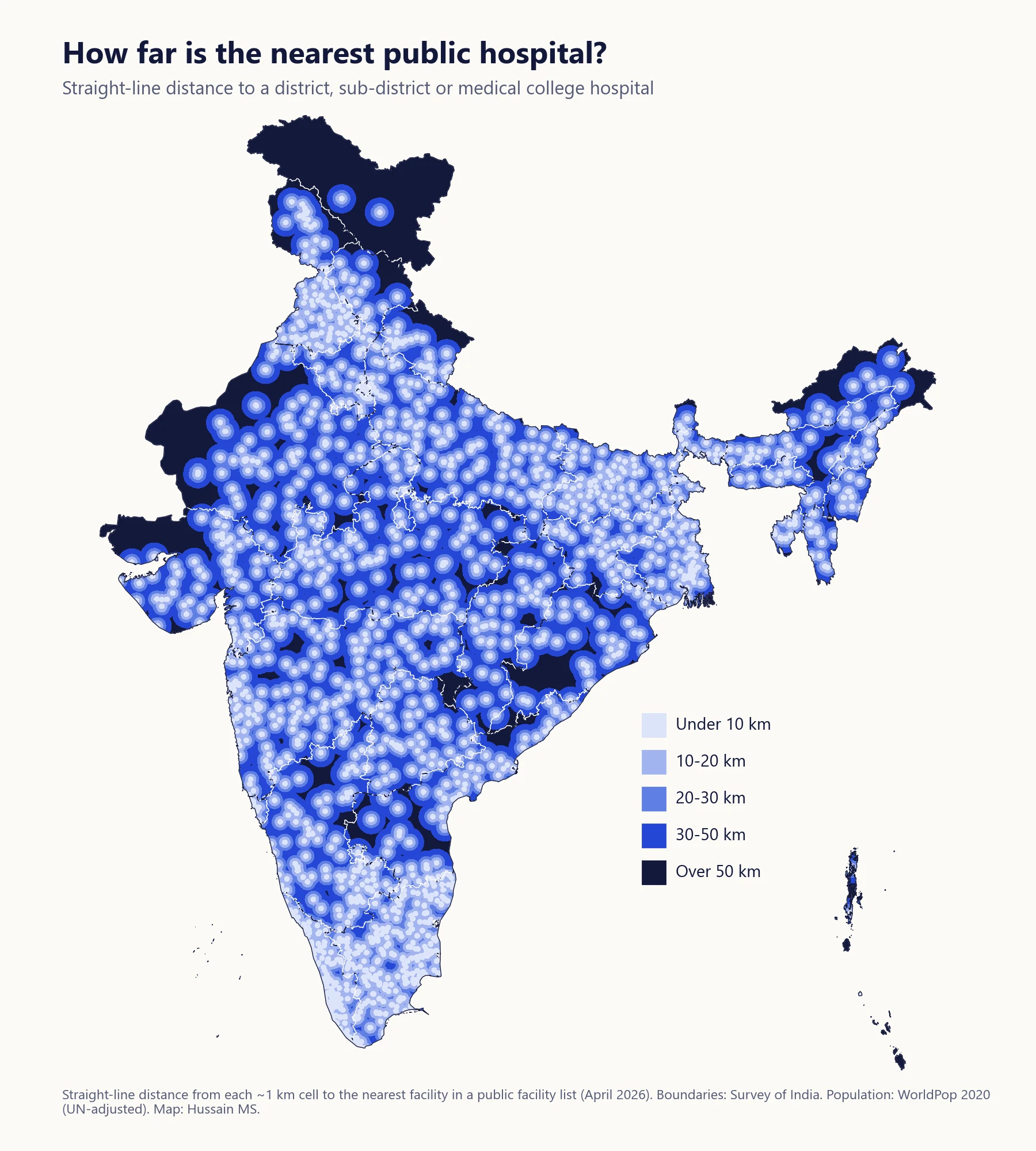
Averaged over land, the straight-line distance to a district, sub-district or medical college hospital is about 30 km. Averaged over people, it is 17 km. The gap exists because the largest empty spaces, the Thar desert, the high Himalaya and eastern Ladakh, are where few people live.
So a map shaded only by distance draws the eye to the remote areas. The dark patches in western Rajasthan, Kachchh and Ladakh are real, and the people who live there face long distances. But they are relatively few. A map of the people who live more than 20 km from one of these hospitals shows something else. Large numbers of them live in densely populated areas across the plains of Uttar Pradesh and Bihar, through central India and along the eastern coast. Understanding what that means for services would need more analysis, of travel times, the role of community health centres, facility capacity, referral patterns and private providers.
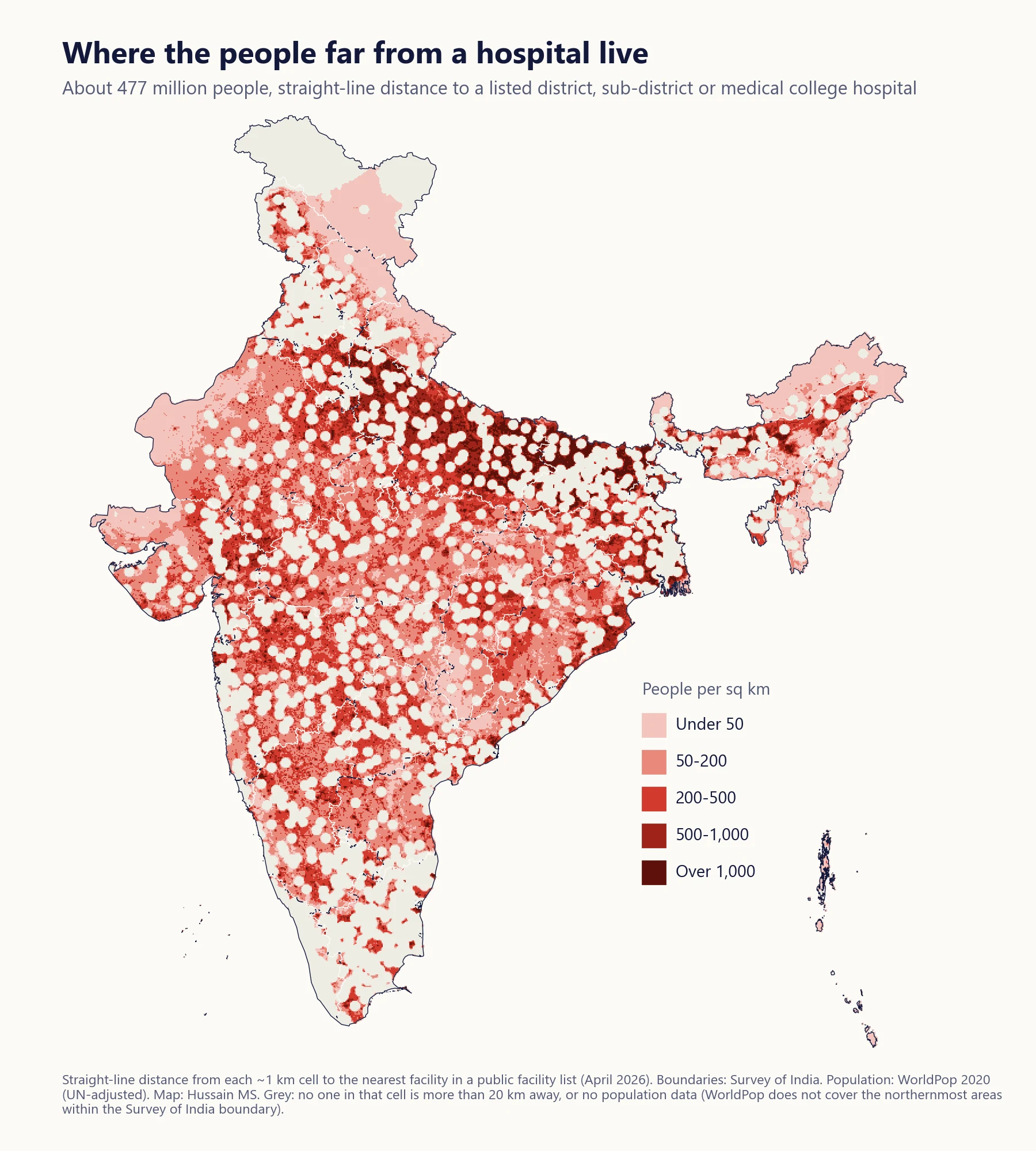 People living more than 20 km in a straight line from a listed district, sub-district or medical college hospital, shaded by density. Community health centres are not counted in this map. Grey areas have no one more than 20 km away, or no population data. Map: Hussain MS.
State averages show the same pattern from another angle. They are descriptive and depend on geography and on how each state’s facilities appear in the list, so they are not a ranking of how states perform. Delhi and Chandigarh sit at about 3 km, Kerala at 7 and Tamil Nadu at 10. Most large states sit between about 15 and 22 km, with Rajasthan (25) and Odisha (28) at the higher end. Ladakh (48 km), Arunachal Pradesh (33) and the Andaman and Nicobar Islands (30) have the largest averages, reflecting their geography.
The farthest inhabited places
These are the ten inhabited squares (25 or more people) farthest in a straight line from a listed district, sub-district or medical college hospital, at least 100 km apart from each other.
| Straight-line distance | Where |
|---|---|
| 289 km | Great Nicobar, southern part (Andaman and Nicobar Islands) |
| 235 km | Western Jaisalmer, near Shangarh (Rajasthan) |
| 191 km | Jaisalmer, near Tonet (Rajasthan) |
| 173 km | Western Kachchh (Gujarat) |
| 154 km | Central Nicobar Islands |
| 145 km | Jaisalmer, near Sam (Rajasthan) |
| 142 km | Eastern Ladakh |
| 135 km | Barmer, near Panohla (Rajasthan) |
| 132 km | Little Andaman (Andaman and Nicobar Islands) |
| 126 km | Kachchh (Gujarat) |
The island rows need particular care. A straight line over water says little about how people actually travel, by boat or by air, and the facility list has only 55 entries for the Andaman and Nicobar Islands, which looks incomplete. The desert and mountain rows point to genuinely sparse places, although the actual journey depends on roads and transport that this analysis does not measure.
What the maps suggest
The first layer of the health system, which brings immunisation, antenatal check-ups and basic treatment to the village, is close to universal in straight-line distance. The bigger question is the next step, how quickly someone can get from that first contact to a facility that can operate, transfuse or resuscitate, and that depends heavily on what community health centres and hospitals can actually do.
In remote areas, improving access may involve transport and referral arrangements, birth waiting homes and stronger local facilities. In densely populated areas, strengthening referral facilities and ambulance coverage are options worth assessing. In both cases, the right choices would depend on local travel times, service capacity and demand, which this analysis does not measure.
The exercise also shows how much depends on the facility list itself. Different type labels across states, and missing entries in some areas, change the answer. Clean and consistent facility registries matter for this kind of planning.
Similar questions are asked globally. The Lancet Commission on Global Surgery proposed that 80% of people in every country should be able to reach a hospital that can perform a caesarean section, laparotomy and treatment of open fractures within two hours. Global travel-time maps by the Malaria Atlas Project make the same kind of calculation along roads for the whole world.
Limits
- Straight line, not travel time. Real journeys are longer, especially in hills, forests and during the monsoon.
- Public facilities only. Private hospitals, which provide much of India’s hospital care, are not in the list.
- Labels, not capability. A listed hospital or health centre may not offer a given service, and some facilities outside these categories may.
- The facility list is uneven. Labels differ between states, and some areas, notably the islands, appear to have fewer entries than they should.
- Indian facilities only. Facilities across international borders are not counted, which can overstate distance near borders.
- Population is modelled. WorldPop estimates where people lived in 2020. It is not a head count, and it does not cover the northernmost areas within the Survey of India boundary.
Sources
- Facility list: government health facilities with coordinates, National Identification Number (NIN) facility directory, April 2026.
- Boundaries: Survey of India, state boundaries.
- Population: WorldPop, Global 1 km population 2020, UN-adjusted. https://www.worldpop.org/
- Meara JG et al. Global Surgery 2030, evidence and solutions for achieving health, welfare, and economic development. The Lancet, 2015.
- Weiss DJ et al. Global maps of travel time to healthcare facilities. Nature Medicine, 2020.
Code available on request.
Views are my own.